
Wildfires can become a tragedy, as the Hawaii fires showed in 2023. Thus early detection is crucial for containing blazes and minimizing damage. But can a weather radar map, often used to track rain and storms, also help us spot forest fires? The answer, like many things, is a nuanced “it depends.”
Traditional weather radar operates by sending out radio waves and analyzing the echoes that bounce back. Rain, hail, and snow are all excellent reflectors of these waves, making them easy to identify on a radar map. But fire itself doesn’t directly interact with radar waves in the same way.
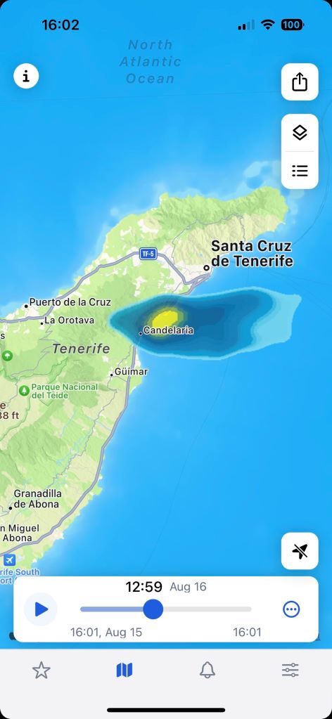
However, there is a crucial indirect way firefighters and meteorologists can use radar technology to spot fires: smoke detection. Large wildfires produce immense plumes of smoke that rise high into the atmosphere. Under the right weather conditions, radar can pick up these smoke plumes. For example, in August 2023, a wildfire raging on Tenerife was so intense that it became visible on the Rain Viewer radar map.
Weather Radar Types
There are two main types of radar used for weather monitoring:
- Traditional radars. These radars focus on the intensity of the returning echo, displaying areas of heavy precipitation as bright colors on the map. While they cannot directly spot a fire, they might reveal a large smoke plume as an area of weaker radar reflectivity. It looks like a negative image where the absence of a strong echo (rain) suggests something else is causing the blockage.
- Doppler radars. These advanced systems not only measure echo intensity but also analyze the shift in frequency of the returning waves. This allows them to determine the velocity of objects like raindrops moving towards or away from the radar. The plumes, while not as strong as rain in terms of movement, can still exhibit a slight Doppler weather radar signature, aiding in their identification.
So how does radar detect wildfires and is there any sense in using weather radar in fire management? The following factors influence the effectiveness of radar observations in spotting forest fires:
Smoke Plume Height
The higher the wildfire plume rises, the more likely it is to be within the range of a radar beam.
Wind Direction
Fire weather radar works best when the wind is blowing the smoke directly towards the radar station. Crosswinds can push the smoke out of the radar’s path, impairing its detection.
Background Weather
Heavy rain or hail can overwhelm the radar signal, making it hard to distinguish smoke.
Radar Capabilities
Advanced Doppler radar offers a higher chance of spotting smoke compared to traditional models.
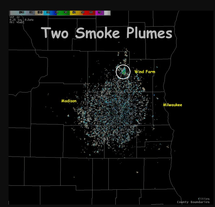 Image source: National Weather Service
Weather Radar Observations in Wildfire Management
Despite these limitations, radar data plays a valuable role in wildfire monitoring and management. Here’s how:
Early Detection
Radar can sometimes identify smoke before a fire is visually spotted, giving firefighters a crucial head start in containing the blaze.
Forest Fire Spread Monitoring
By tracking the movement of the smoke plume on radar, fire crews can see how the fire is spreading and adjust their strategies accordingly.
Fire Intensity Estimation
The size and strength of the radar echo associated with smoke can offer clues about the intensity of the fire.
However, radar is just one piece of the puzzle. Firefighters and meteorologists rely on a combination of tools for comprehensive wildfire management, including:
- Satellite imagery: A satellite can visualize a wildland fire in real-time, even through smoke cover.
- Ground observations. On-site reports from fire crews offer crucial information about fire behavior and fuel conditions.
- Weather forecasts. Understanding wind patterns and humidity levels is critical for predicting how a wildfire might spread.
Radar Wildfire Detection: Conclusion
The future of radar technology in wildfire detection is promising. Researchers are constantly developing new algorithms to improve the ability of radars to differentiate smoke plumes from other atmospheric phenomena. Additionally, the integration of radar data with other fire detection systems is leading to more comprehensive monitoring solutions.
So, traditional radar maps can help fight wildfire by spotting and tracking smoke, even if they do not show flames. This early detection and monitoring capability is crucial for saving lives, property, and valuable ecosystems.