
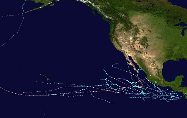
The official 2023 Pacific hurricane season started on May 15 for the eastern Pacific and on June 1 for the central Pacific. However, the Pacific basin was quiet for the first six weeks of the season, making it one of the seasons that began the latest.
The first named storm, Hurricane Adrian, formed on June 27. It was the second-latest first named storm in the eastern Pacific since 1971 when satellites started to track them. Only Tropical Storm Agatha (2016) formed later than Adrian.
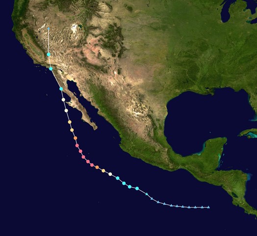
 Source: Wikipedia
This year, several strong hurricanes have hit land. In July, Calvin became the first major hurricane of the season and went near the Big Island of Hawaii as a tropical storm. In August, Dora was a Category 4 hurricane and went south of Hawaii. It may have made the winds stronger over the islands, fueling many wildfires.
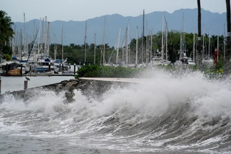
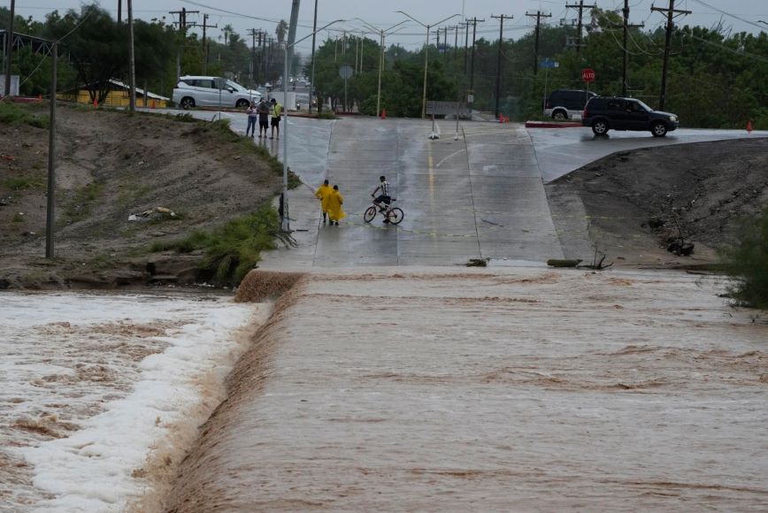
Later in August, Tropical Storm Hilary hit Baja California and brought a lot of rain and wind to the Southwestern United States. In early September, Jova was the first Category 5 hurricane since 2018 in the basin. It brought rain, big waves, and dangerous currents to places that Hilary had already affected.
2023 Pacific Hurricane Season: Main Storms
This year’s season brought six tropical storms, three tropical depressions, eight major hurricanes, and two minor ones. In this article, we’ll be reviewing only the storms with the hurricane status:
- Otis
- Jova
- Dora
- Fernanda
- Hilary
- Lidia
- Norma
- Calvin
- Adrian
- Beatriz
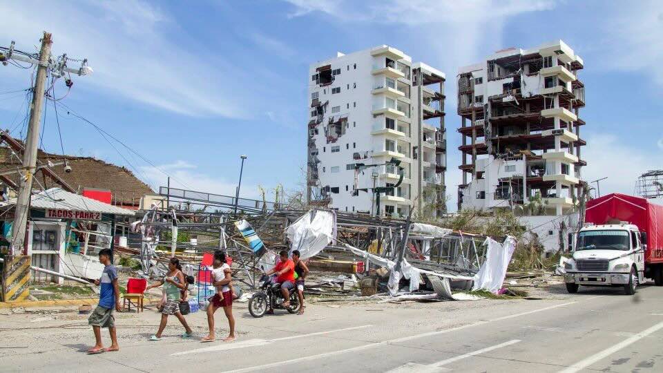
Hurricane Otis
On October 18, a low-pressure area formed south of the Gulf of Tehuantepec. It stayed there for a few days and became a tropical depression on the morning of October 22. Later that day, it became Tropical Storm Otis about 500 mi (805 km) south-southeast of Acapulco.
Otis gained hurricane strength very fast on October 24 and became a powerful 160 mph (260 km/h) Category 5 hurricane. Early on October 25, Otis hit Acapulco at its strongest with winds of 165 mph (270 km/h). In the evening, the hurricane lost its strength quickly over land, became a tropical storm, and dissipated soon after.
Hurricane Otis killed at least 49 people, and 26 more people were missing. This severe weather event caused a lot of damage. Some agencies said it was more than 10 billion USD insured losses. It was greater than the cost of the total damage from all previous hurricanes in Mexico.
 Source: Oscar Guerrero Ramirez/Getty Images
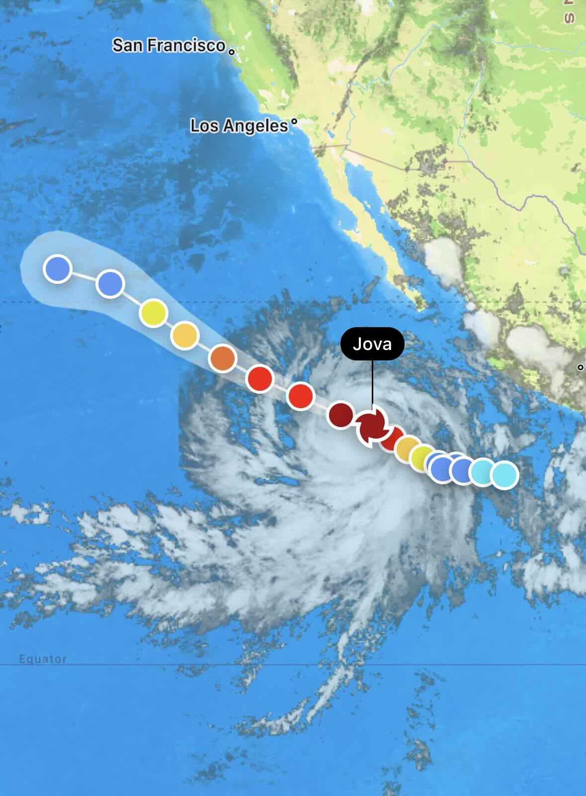
Hurricane Jova
On the first day of September, a tropical disturbance emerged in the far eastern Pacific near El Salvador and Guatemala. The disturbance eventually developed into a low-pressure system south of the southwest coast of Mexico by September 3. On the same day, the National Hurricane Center (NHC) officially designated it as Tropical Depression Eleven-E.
On September 5, south-southwest of Cabo San Lucas, Baja California Sur, the depression intensified rapidly and evolved into Tropical Storm Jova. Within 24 hours, Jova underwent a remarkable transformation. It escalated from a 70 mph (110 km/h) tropical storm to a powerful Category 5 hurricane with sustained winds of 160 mph (260 km/h).
 Source: RainViewer
However, on September 7, Jova began to weaken as changes occurred in its eye structure. The hurricane continued to lose strength on September 8, especially as it traversed cooler waters, downgrading to Category 1 by the afternoon. Subsequently, dry air impacted Jova, leading to further weakening, and it was reclassified as a tropical storm on September 9. By the morning of September 10, the hurricane dissipated. Jova caused rip currents, rainfall, and flooding in Mexico and the southwestern United States.
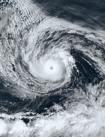
Hurricane Dora
Dora, a robust and enduring storm, traversed all three North Pacific storm regions in August 2023. It originated on July 31 from a cluster of storms in the North Atlantic. Having passed over Central America, Dora intensified into a tropical storm the next day.
 Source: NOAA satellite
Between August 2 and 3, Dora rapidly strengthened, reaching Category 4 hurricane status. During this period, it transitioned from the Central Pacific area to the North Pacific area. The storm lost its circular structure, letting in dry air. This caused the hurricane to move south of Johnston Island. By the morning of August 10, Dora weakened to a Category 3 hurricane. The RainViewer app captured Dora’s movement on its satellite map: [take a look.]{https://twitter.com/RainViewer/status/1687339675336200192/video/1}{:rel=”nofollow”}{:target=”_blank”}
Notably, Dora did not have a direct impact on any landmass. However, the storm produced powerful winds to the south of Hawaii. These winds mixed with a high-pressure system to the north of the islands. This atmospheric interaction may have intensified winds over the islands, contributing to the ignition of the 2023 Hawaii wildfires.
Hurricane Fernanda
A tropical wave formed a low-pressure system off the coast of southwest Mexico on August 11. On August 12, the low became Tropical Depression Seven-E. It then grew stronger and became Tropical Storm Fernanda. The storm moved west-northwest the next day and looked like it was getting stronger quickly. The clouds were very cold and there was clear air flowing out of the top.
An eye-like feature emerged in satellite imagery on the afternoon of August 13, prompting the NHC to upgrade Fernanda to a Category 1 hurricane. The storm underwent a period of explosive intensification, reaching Category 4 status with winds of 130 mph (215 km/h) by afternoon on August 14. Fernanda stayed intense for hours. Then, it weakened to a Category 3 hurricane because of an eye replacement cycle.
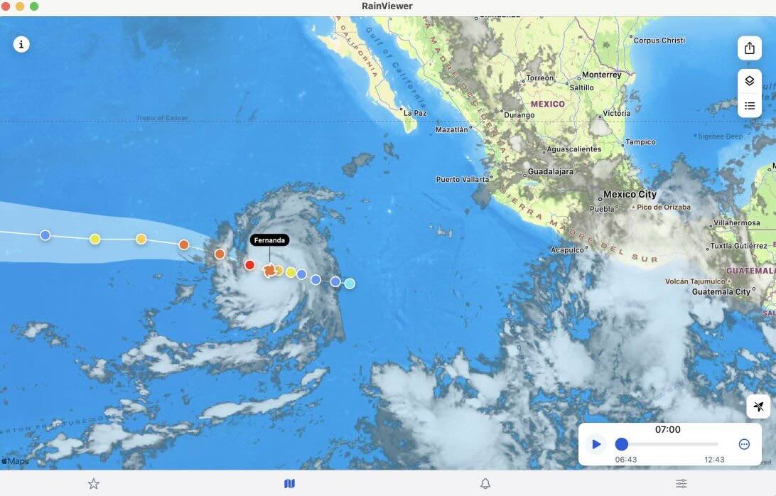 Source: RainViewer
Throughout the remainder of August 14, Fernanda continued to weaken and lost its status as a major hurricane. The storm weakened on August 15 because of bad conditions like wind shear, lower sea surface temperatures, and dry air.
The next morning, Fernanda became a tropical storm. By that night, the storm’s thunderstorms disappeared. Fernanda transformed into a post tropical cyclone on the morning of August 17 far west-southwest of Baja California.
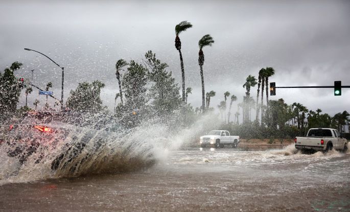
Hurricane Hilary
In August 2023, a formidable Category 4 hurricane named Hilary unleashed its fury upon the Pacific Coast, leaving a trail of destruction. The storm hit Mexico, the Baja California Peninsula, and the Southwestern United States with heavy rain and strong winds, causing widespread flooding and mudslides. In the United States, Hilary set records for the highest rainfall ever recorded from a tropical storm or its remnants in four states.
Hilary’s genesis can be traced back to a turbulent region south of Mexico. There, a series of storms originating from Central America stirred up the Pacific Ocean on August 12. Having united with each other, the storms transformed into Tropical Storm Hilary near Manzanillo, Colima, on August 16. The next day, the tropical storm rapidly intensified into a hurricane.
 Source: Wikipedia
On August 17, Hilary went northwest and changed a lot. It reached its peak intensity as a Category 4 hurricane with wind speeds of 145 mph (235 km/h). However, Hilary’s terror was short-lived. The next day, the storm encountered a combination of cooler waters, dry air, and increased wind shear, causing it to weaken. Reverting to a tropical storm, Hilary made landfall in San Quintín, Baja California, on August 20.
After that, it kept moving north into California as a tropical storm until August 21st. Upon reaching the southern San Joaquin Valley, Hilary transitioned into a post-tropical storm. Notably, Hilary marked the first time since 1997 that a tropical storm had directly impacted California.
Although Hilary was initially worrisome, the storm had a milder impact on the area than anticipated. However, the storm still left a trail of destruction. The storm caused flooding, mudslides, and tree damage in Mexico, killing two people. It also disrupted roads in Baja California and Southern California.
 Source: Mario Tama/Getty Images
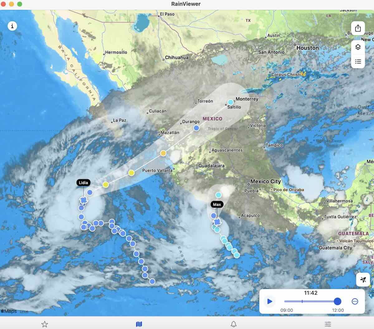
Hurricane Lidia
In late September 2023, a turbulent weather system emerged from the waters south of Mexico. By October 3, it had organized into a tropical storm named Lidia. For several days, Lidia lingered near the Mexican coast, drifting northward while keeping its moderate strength.
Lidia suddenly changed direction on October 9, moving northeast and becoming much stronger. By the early hours of October 10, it had transformed into a hurricane, swiftly reaching Category 4 intensity later that day.
 Source: RainViewer
With ferocious winds of 140 mph (220 km/h), Lidia slammed into the state of Jalisco, becoming the third-strongest Pacific hurricane to make landfall at that time. As it ventured inland over the Mexican mountains, Lidia rapidly weakened and dissipated the following morning over Zacatecas.
The impact of Hurricane Lidia was severe in southwestern Mexico, particularly considering that it struck within 48 hours of Tropical Storm Max affecting the same region. The hurricane caused widespread damage, unleashing torrential rains, severe flooding, and powerful winds that devastated numerous buildings. Airports and schools were closed, and 23 shelters were opened to accommodate displaced residents. The storm also claimed two lives.
 Source: Christian Ruano/Reuters
Hurricane Norma
Emerging from the southern Mexican coast on October 15, 2023, a weather disturbance transformed into Tropical Storm Norma by October 17. Norma swiftly intensified into a Category 4 hurricane as it tracked northward along Mexico’s west coast. Here you can view Norma’s movement as seen by RainViewer’s hurricane tracker.
However, unfavorable weather conditions made it weaker as it approached the Baja California peninsula. Making landfall as a Category 1 hurricane in Baja California Sur, Norma continued to lose strength as the storm moved across the state. The storm reached the Gulf of California on October 22. It weakened even more and hit Sinaloa as a tropical depression the next day. After that, it swiftly dissipated as it traversed Mexico.
Norma wreaked havoc on northwest Mexico, triggering widespread flooding. Some areas in Baja California Sur received nearly 19 inches (480 mm) of rainfall. The cities of Cabo San Lucas and La Paz endured substantial damage to trees, houses, and boats. In Sinaloa, three lives were lost, and numerous homes and businesses suffered.
 Source: Fernando Llano / AP
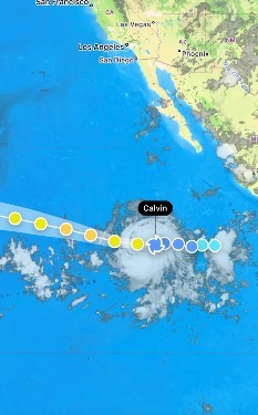
Hurricane Calvin
A storm system emerged off the southern coast of Mexico on July 7. Over the next few days, the system intensified and formed a distinct center by the afternoon of July 11th, becoming Tropical Depression Three-E. The next day, it became Tropical Storm Calvin with a well-defined central cloud mass and organized thunderstorms.
Having moved westward over the open ocean, Calvin found good conditions with low wind and warm water. As a result, it underwent rapid intensification, reaching Category 1 hurricane status on July 13.
The storm continued to strengthen at an exceptional pace, becoming the first major hurricane of the season on July 14. At this time, Calvin displayed a well-defined 17-mile-wide (28 km) eye surrounded by a ring of thunderstorms.
 Source: RainViewer
Later that day, Calvin began to weaken, reverting to tropical storm status by early July 16th. The storm maintained its westward trajectory, crossing into the central Pacific region on July 17th, with sustained winds near 50 mph (85 km/h). By early July 19th, Calvin approached the Island of Hawaii. The interaction with land caused the storm to weaken further and gradually lose its tropical features.
In anticipation of Calvin’s impact, all state parks on the Big Island and most of Hawaii Volcanoes National Park were closed on July 18th. Eight shelters were opened to accommodate residents in need. Fortunately, Calvin’s impact was relatively minor, with limited flooding occurring in flood-prone areas of the Big Island.
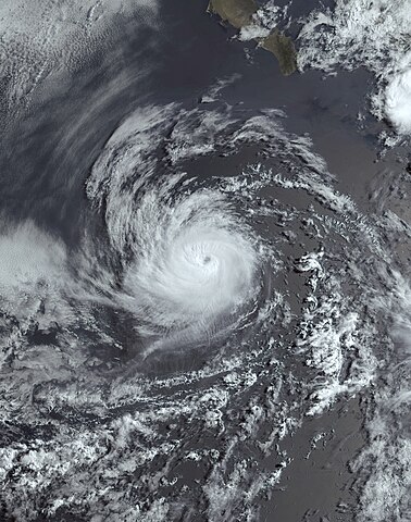
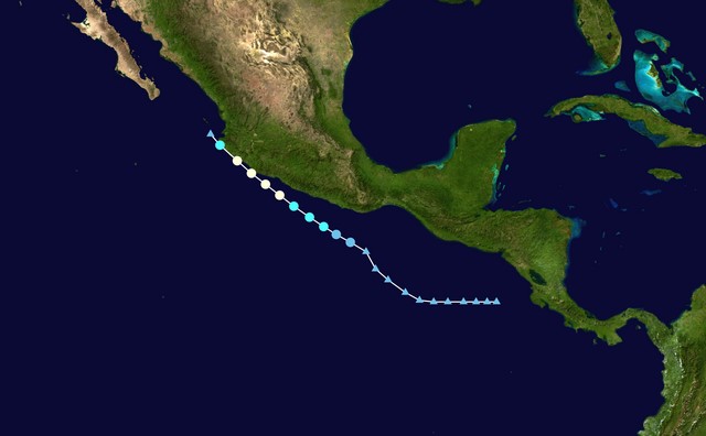
Hurricane Adrian
 Source: NOAA satellite
A low-pressure system emerged off the Mexican coast on June 23, attracting the attention of the National Hurricane Center (NHC). The NHC closely tracked the system’s development over the subsequent days. On June 27, the turbulent weather in the region rapidly consolidated, leading the NHC to officially name it Tropical Storm Adrian.
The next day, Adrian got hurricane status because of its rapid intensification. At that time, it was located approximately 360 miles (580 km) southwest of Manzanillo, Colima. Adrian reached Category 2 hurricane intensity on June 30. Satellite images showed a clear eye surrounded by thunderstorms. However, unfavorable weather conditions, including increased wind shear and cooler water temperatures, caused Adrian to weaken to a tropical storm the following day.
On July 2, Adrian became a weaker storm and turned into a low-pressure system later that day.
Hurricane Beatriz
 Source: Wikipedia
A Pacific hurricane named Beatriz brought widespread flooding across southwestern Mexico in late June and early July 2023. Beatriz formed from a low-pressure area that emerged off the southern coast of Mexico on June 25.
The system took some time to develop, but because it was a potential threat to the Mexican coast, it was monitored as Potential Tropical Cyclone Two-E. The system became a tropical depression six hours later. On the same day, the depression intensified into a tropical storm and received the name Beatriz.
Beatriz moved close to the coast of Mexico and quickly became a hurricane on June 30. The storm reached its peak strength soon after, with maximum sustained winds of 85 mph (137 km/h).
Early on July 1, the center of the hurricane reached the coast near Punta San Telmo, and then it began to weaken. Beatriz was downgraded to a tropical storm shortly after and then disappeared completely off the coast of Cabo Corrientes. The hurricane caused heavy rains and flooding in several Mexican states, but in general, the damage from it was minor.
2023 Pacific Hurricane Season: Summary
We’ve summarized all tropical cyclones and hurricanes that occurred over the Pacific Ocean during the 2023 season.
| Name | Dates | Max.Category |
|---|---|---|
| Adrian | June 27 – July 2 | Cat 2. hurricane |
| Beatriz | June 29 – July 1 | Cat.1 hurricane |
| Calvin | July 11–19 | Cat.3 hurricane |
| Four-E | July 20-21 | Tropical depression |
| Dora | July 31 – Aug 11 | Cat.4 hurricane |
| Eugene | August 5-7 | Tropical storm |
| Fernanda | Aug 12-17 | Cat.4 hurricane |
| Greg | Aug 14-17 | Tropical storm |
| Hilary | Aug 16-21 | Cat.4 hurricane |
| Irwin | Aug 27-29 | Tropical storm |
| Jova | Sep 4-10 | Cat. 5 hurricane |
| Twelve-E | Sep 15–17 | Tropical depression |
| Kenneth | Sep 19–22 | Tropical storm |
| Fourteen-E | Sep 23-25 | Tropical depression |
| Lidia | Oct 3-11 | Cat.4 hurricane |
| Max | Oct 8-10 | Tropical storm |
| Norma | Oct 17-23 | Cat.4 hurricane |
| Otis | Oct 22–25 | Cat. 5 hurricane |
| Pilar | Oct 28-Nov 6 | Tropical storm |