
Tornadoes are nature’s formidable force that can wreak havoc and instill fear in the hearts of those in their path. To understand and mitigate the impact of these swirling tempests, scientists use various metrics to define their intensity and characteristics. In this article, we will delve into the methodologies and instruments used for the measurement of these powerful atmospheric phenomena. But first, let’s refresh the general tornado knowledge.
What Is a Tornado and How Does It Form?
A tornado is a strong vortex that forms during hot weather under a well-developed cumulus cloud. It then spreads to the earth or water body in the form of a giant dark rotating column or funnel. The vortex has a vertical axis of rotation that can slightly incline to the horizon. The height of a tornado may reach hundreds of feet, in some cases up to 1 mile. The diameter may be 30 to 100 ft (10-30 m).
A tornado typically lasts between a few minutes and an hour or more. For example, the Mattoon-Charleston tornado of 1917 is considered to be the longest-lasting one. It lasted 7 hours and 20 minutes and traveled 310 miles (500 km) during this time.
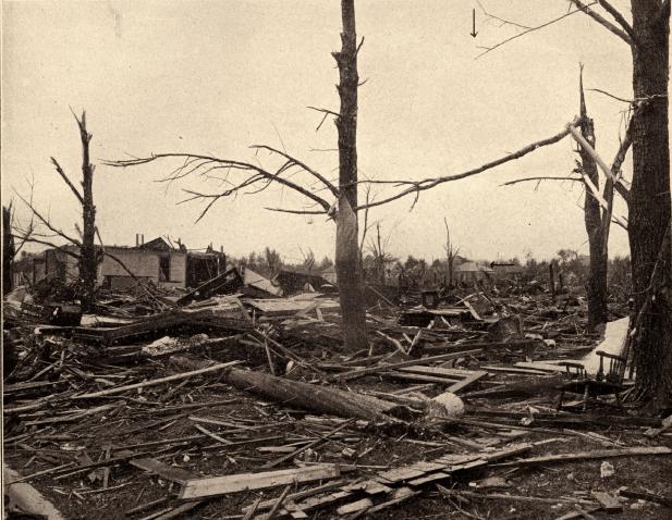 Image source: Wikipedia
Tornado wind speeds may reach 60 mph (96 km/h). A tornado is most often accompanied by heavy rain and thunderstorms, sometimes hail. In the center of a tornado, there is a low-pressure area, that’s why the whirlwind sucks in all that meets on the way. It can lift water, soil, individual objects, and buildings, carrying them sometimes to significant distances.
Tornadoes form under powerful cumulonimbus clouds as a result of the interaction of very strong upward and downward flows associated with movements in the cloud.
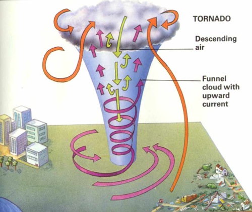 Image source: The Whyville Times
In its development, each tornado passes through the following stages:
- the initial funnel formation from the storm cloud;
- the vortex of maximum power (when the funnel touches the ground);
- and vortex collapse, when the funnel breaks away from the ground and rises into the parent cloud.
Understanding the Metrics: How Are Tornadoes Measured?
The most destructive tornadoes occur in the USA. For example, see this breathtaking drone footage of a tornado in Kansas by Reed Timmer, a famous storm chaser.
To determine the strength of tornadoes in the U.S., the 5-category Fujita-Pearson scale was developed. In 2007, it was replaced by the Enhanced Fujita Scale.
Enhanced Fujita (EF) Scale: A Graded Assessment
One of the most widely used systems for classifying tornadoes is the Enhanced Fujita (EF) scale. Developed by Dr. Theodore Fujita in collaboration with engineer Allen Pearson, this scale categorizes tornadoes based on their estimated wind speeds and associated damage. The EF scale rates the tornado intensity from EF0 (weakest) to EF5 (strongest) by looking at the damage they cause to buildings, plants, and objects.
| Enhanced Fujita Scale | ||
|---|---|---|
| EFU | Unknown | No surveyable damage |
| EF0 | 65–85 mph | Light damage |
| EF1 | 86–110 mph | Moderate damage |
| EF2 | 111–135 mph | Considerable damage |
| EF3 | 136–165 mph | Severe damage |
| EF4 | 166–200 mph | Devastating damage |
| EF5 | >200 mph | Incredible damage |
Table source: Wikipedia
Doppler Radar: Peering into the Heart of the Storm
Modern weather technology has significantly advanced tornado measurement capabilities. Meteorologists use Doppler radar, a cornerstone in tornado detection, to examine the internal structure of a tornado. By assessing the movement of raindrops or debris within a storm, the Doppler technology provides valuable information about the tornado’s rotation, speed, and potential for intensification. This real-time data is crucial for issuing timely warnings and enhancing preparedness.
Mobile Radar Units: Chasing Tornadoes for Science
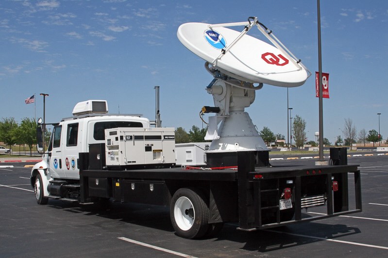 Image source: NOAA
In addition to stationary radar installations, researchers and storm chasers use mobile radar units. These vehicles are equipped with radar systems, allowing scientists to get close to tornadoes while remaining mobile. By collecting data from different angles and distances, mobile units make it easier to understand tornado vortex dynamics and thus refine forecasting models.
Tornado Damage Surveys: Piecing Together the Puzzle
Tornadoes leave a distinctive footprint of destruction in their wake, and scientists leverage this aftermath to gauge their strength. The surveys involve on-site inspections of affected areas, documenting the destruction to determine the Enhanced Fujita scale rating. This method provides a ground-truth validation of radar data, improving tornado forecasting and resilience.
Tornado Debris Signature Analysis: Unveiling the Invisible
An innovative tornado measurement method involves analyzing the debris signature left behind by a tornado. Radar systems can spot and track debris carried by the tornado, providing valuable information about its intensity and potential threat. This method helps evaluate tornadoes in remote or unpopulated areas where surveys may be challenging.
Conclusion
Measuring tornadoes is a multifaceted process that combines historical analysis, cutting-edge technology, and real-time observations. The EF scale, radar, mobile units, damage surveys, and debris signatures collectively contribute to our understanding of tornadoes, enabling meteorologists to issue timely warnings.